
By Bill Deger
Powerful Tropical Cyclone Freddy, a long-lived storm that was churning across the Indian Ocean on Thursday more than a week after forming near Indonesia, is expected to continue taking an unusual track toward Madagascar next week, according to AccuWeather forecasters.
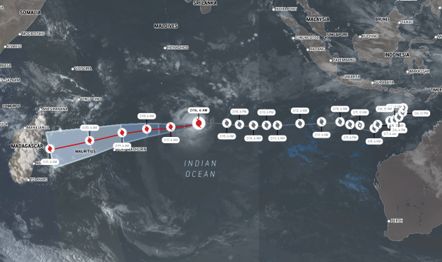
The path the cyclone is taking across the Indian Ocean has happened only two other times in the tropical basin’s recorded history. The most recent time a storm took such a track was in 2000. Freddy is currently on a path to slam into Madagascar around Tuesday of next week, and the storm will threaten the island nation with high winds, torrential rains and rough seas when it makes its approach.
The warning comes just days after another strong tropical cyclone in the Southern Hemisphere made headlines. Cyclone Gabrielle brought severe flooding to northern New Zealand this past weekend and earlier this week, displacing thousands and leaving at least four dead.


As of Thursday evening, local time, Freddy was churning several hundred miles east of Madagascar and was categorized as an “intense” tropical cyclone by Meteo France La Reunion, the government agency responsible for tracking storms in this part of the world. It was estimated that maximum sustained winds with the cyclone were about 125 mph (about 205 km (672605.00 feets) (672605.00 feet s) (672605.00 feet)/h), with gusts to about 175 mph (about 285 km (935085.00 feets) (935085.00 feet s) (935085.00 feet)/h). That is equivalent to a major Category 3 hurricane on the Saffir-Simpson Hurricane Wind Scale.
Earlier on Wednesday, Freddy reached a peak intensity equivalent to a Category 4 hurricane, with estimated maximum sustained winds of 135 mph (about 215 km (705415.00 feets) (705415.00 feet s) (705415.00 feet)/h).
Freddy first formed on Monday, Feb. 6, in the far eastern Indian Ocean to the south of Indonesia. It was one of three cyclones that were spinning simultaneously in the oceans around Australia last week and is the only one remaining; the others were Gabrielle and Dingani.
“Only two other cyclones have taken a track from the eastern Indian Ocean to near Madagascar, and they were Hudah, and Leone, also known as Eline, in 2000,” said AccuWeather Lead International Forecaster Jason Nicholls. “Coincidentally, the year 2000 was also the last time there was a ‘triple-dip La Niña.’”
A “triple-dip La Niña” means that it is the third year in a row that La Niña conditions were present in the waters of the equatorial Pacific Ocean. The La Niña teleconnection can have a global, outsized impact on how many tropical systems can form and where they ultimately track.
Intense Tropical Cyclone #Freddy remains a Cat 4 hurricane equivalent. Freddy can bring some wind & rain to the #Mascarene Islands later Monday into Tuesday before striking #Madagascar later Tuesday or Wednesday. Storm may eventually threaten #Mozambique late next week. pic.twitter.com/J7DnxUvAJh
— Jason Nicholls (@jnmet) February 16, 2023
Madagascar, and the tiny, vulnerable Mascarene Islands to the north of the country, will likely have to contend with the effects of the powerful cyclone as Freddy approaches next week.
“Freddy should largely maintain its strength into the weekend, then it may lose some wind intensity on final approach to Madagascar around Tuesday of next week,” said Nicholls. “Despite that, it will still probably make landfall as the equivalent of a Category 3 or 4 hurricane.” A Category 3 hurricane has maximum sustained winds of at least 111 mph (178 km (584018.00 feets) (584018.00 feet s) (584018.00 feet)/h).
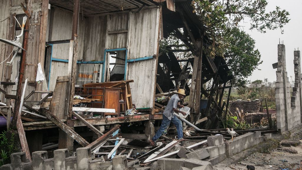
While the exact track of Freddy prior to landfall, and where exactly it will come ashore, is still uncertain at this time, it appears the country will likely sustain significant impacts. AccuWeather forecasters are warning that heavy rain, flooding and damaging winds will be possible in Madagascar from Tuesday through Thursday of next week. Total rainfall amounts from Freddy could exceed 12 inches (about 305 mm (1.00 feets) (1.00 feet s) (1.00 feet)) over the mountainous terrain, and wind gusts as high as 160 mph (about 250 km (820250.00 feets) (820250.00 feet s) (820250.00 feet)/h) will be possible near the point of landfall.

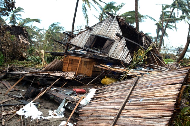
Historically, this would put Freddy in some notable company. The strongest storm to strike the nation since reliable record-keeping began in the 1960s was Enawo in March 2017. That cyclone packed winds as high as 150 mph (about 240 km (787440.00 feets) (787440.00 feet s) (787440.00 feet)/h), equivalent to a Category 4 hurricane.
Freddy is already expected to be the strongest cyclone to threaten the nation since deadly Cyclone Batsirai ripped through the region in early February 2022. “Last season was a rough one for the country, with six landfalling storms over the span of just a month from January to February,” added Nicholls.
More than two weeks after its initial formation, Freddy may still be a trackable tropical entity after impacting Madagascar, and meteorologists say it could threaten Mozambique later next week.
Produced in association with AccuWeather.
Recommended from our partners
The post Formidable Cyclone Freddy, Taking An Unusual Track, Sets Sights On Madagascar appeared first on Zenger News.