

Hurricane season is officially here. To help raise awareness on hurricane hazards and the scientific resources available to at-risk communities, the U.S. Geological Survey created a short quiz on coastal storms.
In which direction do hurricanes spin?
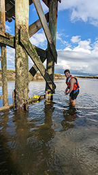
USGS scientist Robert Bales attaches a pressure sensor to a post in the Sandwich Marsh tidal creek in Massachusetts to measure water level during Hurricane Lee. Photograph Credit: Chris Sherwood, USGS.
The correct answer: C. Both clockwise and counterclockwise. North of the equator, hurricanes spin counterclockwise, which is north to west. South of the equator, hurricanes spin clockwise, which is south to east. This information helps USGS scientists forecast potential impacts to coastlines such as where storm surge, erosion and inundation could occur.
True or false? The eye (center) of a hurricane is the calmest part.
- True
- False
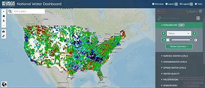
The correct answer: A. True. The eye, which is the center of a hurricane, is typically the calmest part, with strong wind and precipitation occurring outside of the eye. During significant rainfall, the USGS nationwide network of permanent streamgages is particularly valuable. Those gauges are in rivers and streams and provide data on water levels, with most collecting data on streamflow too. Streamgages give insight on current and potential floods as well as drought conditions. Data from these and other instruments can be seen on the USGS National Water Dashboard and USGS Flood Event Viewer. The public can sign up to receive updates about water conditions through the USGS WaterAlert system.
How many named storms are forecast by the National Oceanic and Atmospheric Association for the 2024 Atlantic hurricane season?
- 1 to 9
- 8 to 16
- 17 to 25
- 26 to 34

Three people inside a plane wearing flight suites and helmets, two are seated, one is standing looking at them
The USGS participates in a collaborative effort with partners to deploy 11 buoys from a U.S. Navy aircraft in preparation for Hurricane Lee. The correct answer: C. 17 to 25. A range of 17 to 25 total named storms are forecast for the 2024 Atlantic hurricane season by NOAA. The forecast for named storms, hurricanes and major hurricanes is the highest NOAA has ever issued for their outlook, which is released in May. For advice on how to build an emergency kit or prepare for a range of disasters and emergencies such as hurricanes, people can visit ready.gov or listo.gov.
Was the 2023 Atlantic hurricane season above average, average or below average?
- Above average
- Average
- Below average
The correct answer is a) Above average. There were 20 named storms in the Atlantic basin in 2023, and an average season has 14. When a storm intensifies, 3D topographic data from the USGS can help communities prepare for and assess impacts. The USGS collects data and produces high-resolution images using a technology called Light Detection and Ranging. Lidar data are collected by aircraft using pulses of light that reflect off the ground’s surface, vegetation and buildings. Elevation data can help identify areas, particularly in low-lying regions, at-risk to storm-tide inundation and floods.
What type of scientist studies hurricanes and their impacts?
- Biologist
- Hydrologist
- Geologist
- Oceanographer
- Geographer
- All of the above
Scroll down below the image to see the answer.
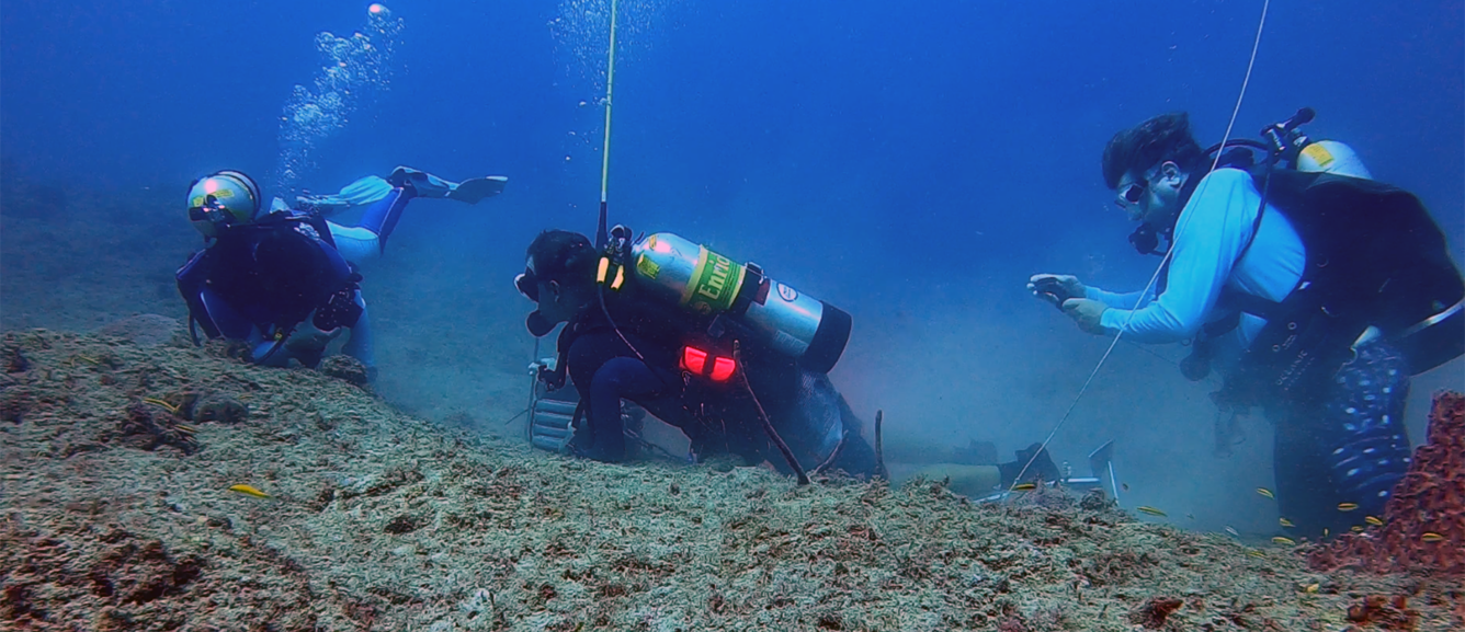
Three U.S. Geological Survey scientists in scuba gear work to install a wave buoy and pressure sensor 60 feet underwater to measure waves and water levels in Isla Verde, Puerto Rico. USGS Image.
Sources/Usage: Public Domain. View Media Details
Three USGS scientists in scuba gear work to install a wave buoy and pressure sensor 60 feet underwater to measure waves and water levels in Isla Verde, Puerto Rico. Photograph Credit: USGS.
The correct answer: F. All of the above. Many people might first think of meteorologists, and there are several other research fields that can involve studying hurricanes and their impacts. For example, the USGS has biologists who help assess the spread of non-native species following storms, hydrologists that measure rivers and streams and monitor flooding, geologists that help determine the potential for landslides after intense rainfall, oceanographers that study how the coast has and could change, geographers that create detailed maps of coastal areas at risk to storm impacts and many more types of scientists! When storms threaten the nation’s coast, the USGS works with several partners to provide valuable and comprehensive hurricane science.
6. Which of these invasive species could potentially spread following storms and floods in North America?
A. Amazon Sailfin Catfish
B. Giant apple snails
C. Options A and B
Scroll down below the image to see the answer.
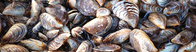
Zebra mussels, an invasive species that threatens U.S. waters.
Sources/Usage: Public Domain. View Media Details
Photograph of a zebra mussel. Photograph Credit: Dave Britton, U.S. Fish and Wildlife Service.
The correct answer: C. Options A and B. With that said, there are thousands of known nonindigenous aquatic species in the U.S. Flooding following extreme storms can cause many animal and plant species to move to new locations and become invasive, posing concerns to ecosystems and the economy. Those include Amazon Sailfin Catfish, giant apple snails, zebra mussels (photographed above), African Jewel Fish and more. The USGS creates maps to track which non-native and invasive species could potentially be transported by floodwater. The maps can help natural resource managers identify at-risk areas and develop watchlists to look out species of concern.
What is the rise in total water level called that is produced by coastal storms?
- Water storm
- Storm tide
- Wave sweep
Scroll down below the images to see the answer.
Sources/Usage: Public Domain. View Media Details
Section of Big Hickory Beach in Bonita Beach, Florida, before and after Hurricane Ian in 2022. The USGS uses remote sensing techniques such as satellite and aerial imagery to analyze changes to the coast following storms. Photograph Credit: USGS.
The correct answer: B. Storm tide. Storm tide is the total water level during a storm. The high-speed winds accompanying a hurricane can cause sea level to rise above normal levels, and that wind can also push water and waves from the ocean towards the shore. As that water reaches land, it can inundate coasts, which can be exacerbated by precipitation and river runoff. Prior to a hurricane making landfall, USGS field crews may install storm-tide sensors on bridges, piers and other structures along a storm’s projected path. Those sensors continuously record the timing and height of flood water.
Start with science
Scientists with the USGS are dedicated to studying coastal storms so robust data are available to the people who need it. The USGS monitors potential impacts from a range of storms along all coastlines in the contiguous U.S. as well as Alaska, Hawaii, Puerto Rico, the U.S. Virgin Islands and Guam.
USGS science helps storm forecasters, emergency responders, communities, resource managers and other decision-makers prepare for, cope with and recover from storms.
Hurricane season In the Eastern North Pacific officially begins May 15 and ends November 30, and the North Atlantic and Central North Pacific begins June 1 and ends November 30. While hurricanes are of most concern during those months, storms can occur outside of hurricane season in any given year.
If you would rather not receive future communications from United States Geological Survey