By Hannah Levitan
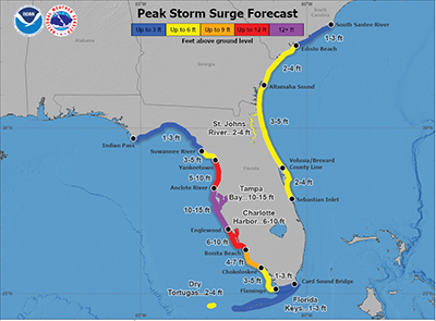
As Hurricane Milton quickly approaches Florida, the National Hurricane Center in Miami has forecasted storm surge to reach up to 15 feet across parts of Florida’s west-central coast, a rare peak level in the U.S.
The NHC, which forecasts projected peak storm surge levels across swaths of areas expected to be impacted by a hurricane, has only used graphics calling for such a high storm surge, above 12 feet, in two other instances.
Storm surge, often the most dangerous part of a hurricane, is defined as an unusually high water level caused by a tropical cyclone.
One of the worst surges in history, caused by Hurricane Opal in 1995, made landfall near Pensacola Beach, where tides reached over 24 feet in Fort Walton Beach. And during Hurricane Katrina, water levels reached between 25 to 28 feet along the Mississippi Coast.
Milton ‘going to be a bad event’
Using the color purple to indicate life-threatening water levels, meteorologists predict the storm could reach up to 20 feet for Milton. And according Robbie Berg, a hurricane forecaster for NHC, “Milton has the potential to be one of the most destructive hurricanes on record for west-central Florida.”
The last time on record that Tampa had 15 feet of storm surge was in 1848, said Phil Klotzbach, a hurricane researcher at Colorado State University. That storm hit the area in a similar track as the Milton forecast.
“Any way you slice it, this is going to be a bad event,” Klotzbach said.
Milton peak surge 10/8
Just two weeks ago, Hurricane Helene brought more than eight feet of water along the Gulf Coast and devastated the community. Before Helene made landfall, NHC projected a surge of 12 feet. Along with Hurricane Ian, Helene was one of the only other two hurricanes where the NHC forecast called for such drastic storm surge levels.
Storm surge threats from Milton
Though weather forecasters predict the storm to hit the west coast by Wednesday night, Florida residents should expect Milton to zig zag. Berg warns the NHC’s predictions could be off by 60 to 70 miles, making the landfall prediction difficult to pinpoint.
By the time the hurricane makes landfall, Milton’s wind field is forecasted to double in size, intensifying its impact on Florida’s west coast.
Since Florida’s west coast is more shallow, it’s likely the storm will have a greater impact on the Gulf Coast and create a more severe hazard. With little room to dissipate, a storm surge cannot spread out and, instead, is quickly pushed up onto the coastline, according to the National Weather Service. Though Milton will impact both coasts, the east coast’s surge is projected to reach around six feet.
Residents are advised to follow local evacuation orders and take proper measures if they are in a surge area. Forecasters have emphasized that all preparations ahead of Milton should be complete by Tuesday night.
Times-Picayune reporter Kasey Bubnash contributed to this report.

