City encourages neighbors to be prepared for seasonal high tides
Submitted by Tracy Roach
The City of Fort Lauderdale is a coastal community with numerous low-lying areas and 300 miles of canal coastline. From time to time we experience severe flooding associated with extreme weather events such as tropical storms and hurricanes. Flooding might also occur as a result of inclement weather conditions including prolonged heavy rains, storm surge and seasonal high tides. These conditions are expected to worsen with projected sea level rise increases associated with climate change.
While the City maintains an extensive storm water master plan and is instituting both aggressive maintenance and innovative adaptation solutions to address drainage, the location and natural geography of our city makes us susceptible to flooding.
The City of Fort Lauderdale is providing the following information to educate and inform our neighbors about seasonal high tides in an effort to help everyone be better prepared for these types of weather events.
What is a Tide?
The word “tide” is a generic term used to define the rise and fall of sea level with respect to land. Tides are influenced by the gravitational attraction of the moon and sun. In addition, tides are affected by other factors such as: coastline configuration, local water depth, wind, and weather conditions. Twice a day, tides peak to a high and low water level, commonly referred to as “high tide” and “low tide.”
Knowledge of the tide times and predicted heights are important to various applications such as: emergency preparedness; maritime navigation; the construction of bridges, docks, and seawalls; and the operation of wastewater and storm water collection systems. Tide information is indispensable to the fishing, boating, surfing, and other water-related industries. Currently, this information is critical to understanding flooding which impacts the City during weather events, particularly in low-lying areas.
Tide Predictions
Tide predictions can differ from the actual sea level rise or fall that occurs. Predicted tidal heights are those expected during average weather conditions. When weather conditions differ from what is considered average, water levels can be significantly altered. Generally, prolonged onshore winds (wind towards the land) or low barometric pressure can produce higher sea levels than predicted, while offshore winds (wind away from the land) and high barometric pressure can result in lower sea levels than predicted.
High tides are produced from the flow of water toward positions on Earth where the gravitational forces of the sun and moon are the strongest. Low tides are created at a point midway between the two positions. The alternating between high and low tides is caused by the daily rotation of the Earth. There are peak high tides in each month. Typically the City of Fort Lauderdale experiences its highest tides during the months of September, October, and November.
These high tides may cause ocean and canal waters to rise above elevations of land, including streets in low-lying areas of Fort Lauderdale and throughout South Florida, thus causing tidal flooding of those areas.
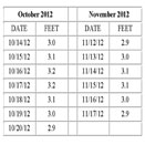
High Tide Table
The table below provides specific dates when tides are expected to be six inches higher than an average high tide at the Andrews Avenue Bridge in October and November 2012.
Flood Prevention Information
The City of Fort Lauderdale’s website, www.fortlauderdale.gov, provides detailed information about flooding including zones, hazards, safety, protection and prevention. The site includes links to useful guides, maps and resources from the City, Broward County, Federal Emergency Management Agency (FEMA) and other organizations.
Neighbors may visit the following links for additional information:
Floods and Flood Zone Information
https://www.fortlauderdale.gov/hurricane/hurr_flood.htm
2012 Flood Guide
https://www.fortlauderdale.gov/hurricane/pdf/flood_guide.pdf
Flood Prevention Information
https://www.fortlauderdale.gov/public_services/environmental_services/flood.htm
Flood Protection Flyer
https://www.fortlauderdale.gov/hurricane/pdf/flood_flier.pdf
Neighbors with questions or concerns about flooding may contact the City’s 24-Hour Customer Service Center at (954) 828-8000 or online at www.fortlauderdale.gov/customerservice.
Customer Service may also be reached via LauderServ, the City’s Android-based mobile application. For more information about LauderServ or to download the application, please visit www.fortlauderdale.gov/lauderserv.


Be the first to comment